 Palo Alto Stanford Heritage
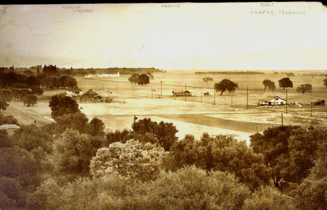
This photo shows part of Seale Addition #1 as it appeared circa 1912. Seale Addition #1 is that portion of Palo Alto running from Embarcadero Rd. to Seale Ave, between Alma and Middlefield Rd. This tract was envisioned as a suburb of Palo Alto—itself built on land once owned by the Seale family—as early as 1898 and subdivided by Alfred Seale in 1904. Being outside the city limits at the time, construction could not begin, however, until water was provided. This Seale did by digging an artesian well at 1635 Bryant St.
This photo was undoubtedly taken from a water tower atop the Bryant Street well. The view is towards the east. The gap in the trees on the horizon is where San Francisquito Creek flowed into the Bay with the original willow groves (sausal) standing on each side. The four houses in the frame can be identified by the names at the top of the picture: "Thorild" and "Hagerty" to the left, "Manning" in the center, and "Engle" to the right. The white Engle house is labeled as being near the corner of Cowper and Tennyson. This was the home of Alfred J. Engle at 520 Tennyson Ave. It remains today looking much as it does in this picture. According to the current owner (who inherited the house from her mother), Engle began pouring the foundation of this house as early as 1906, but didn't finish it until several years later.
Cowper St. runs across the center of the photo with open wheat fields on either side. Tennyson Ave. is the street lined with telephone poles running diagonally to the upper left. One block up, at the corner of Webster St., can be found the home of Prof. William A. Manning at 604 Tennyson. At the time, this home had only a single story and was covered in redwood shingle. Between it and the large valley oak to its right will be seen a small shed. This is an early outhouse. The two houses on Webster to the left are those of John A. Hagerty at 1934 Webster and the Frederick Thorild family at 1930. Thorild, a native of Sweden, was a realtor and lived here before moving to 356 Kingsley in the mid 1920s.
Seale Ave. (originally named "Milton Avenue," but changed to "Seale" after the death of Alfred's father, Thomas, in early 1907) runs beyond and parallel to Tennyson towards the large white building just below the horizon. This I take to be a barn in which the Seales at one time stored their hay. It would be about where the Congregational Church of today stands at the corner of Embarcadero and Louis.
(Seale Addition #2 was that part of the Seale Tract lying between Seale and Oregon Avenues. It included the original Seale ranch house *, which once stood near the corner of Webster St. and California Ave. It began to be developed in 1917, at which time Seale Addition #1 was annexed by the City of Palo Alto. Taken together, both areas today are commonly referred to as “Old Palo Alto.” Between the two World Wars, however, these would have been considered “new” parts of town.)
| |
E-mail us at either webmaster@pastheritage.org or president@pastheritage.org.
![]() Palo Alto Stanford Heritage—Dedicated to the preservation of Palo Alto's historic buildings.
Palo Alto Stanford Heritage—Dedicated to the preservation of Palo Alto's historic buildings.
Copyright © 2015 Palo Alto Stanford Heritage. All rights reserved.